Chicago is the closest megalopolis to me, and the second most important city in the history of American type machinery.
These are just my own notes for useful resources in researching the history of Chicago (my own interests are in the history of the printing/typefounding industry and to a lesser extent the metalworking industry).
Note: For telephone exchange information, see Useful Date Indicators.
The "Forgotten Chicago" website contains a small but good collection of digitized maps of Chicago (as well as useful links to other sources). Their map site is at:
http://forgottenchicago.com/resources/maps/maps/
In my own research, their 1910 and 1938 maps are the most useful. The maps they have include:
For maps generally at the Library of Congress, see: http://www.loc.gov/maps/collections/
For "panoramic maps" of various US cities, mostly 19th century, see the US Library of Congress' Panoramic Maps collection at: http://www.loc.gov/collections/panoramic-maps/
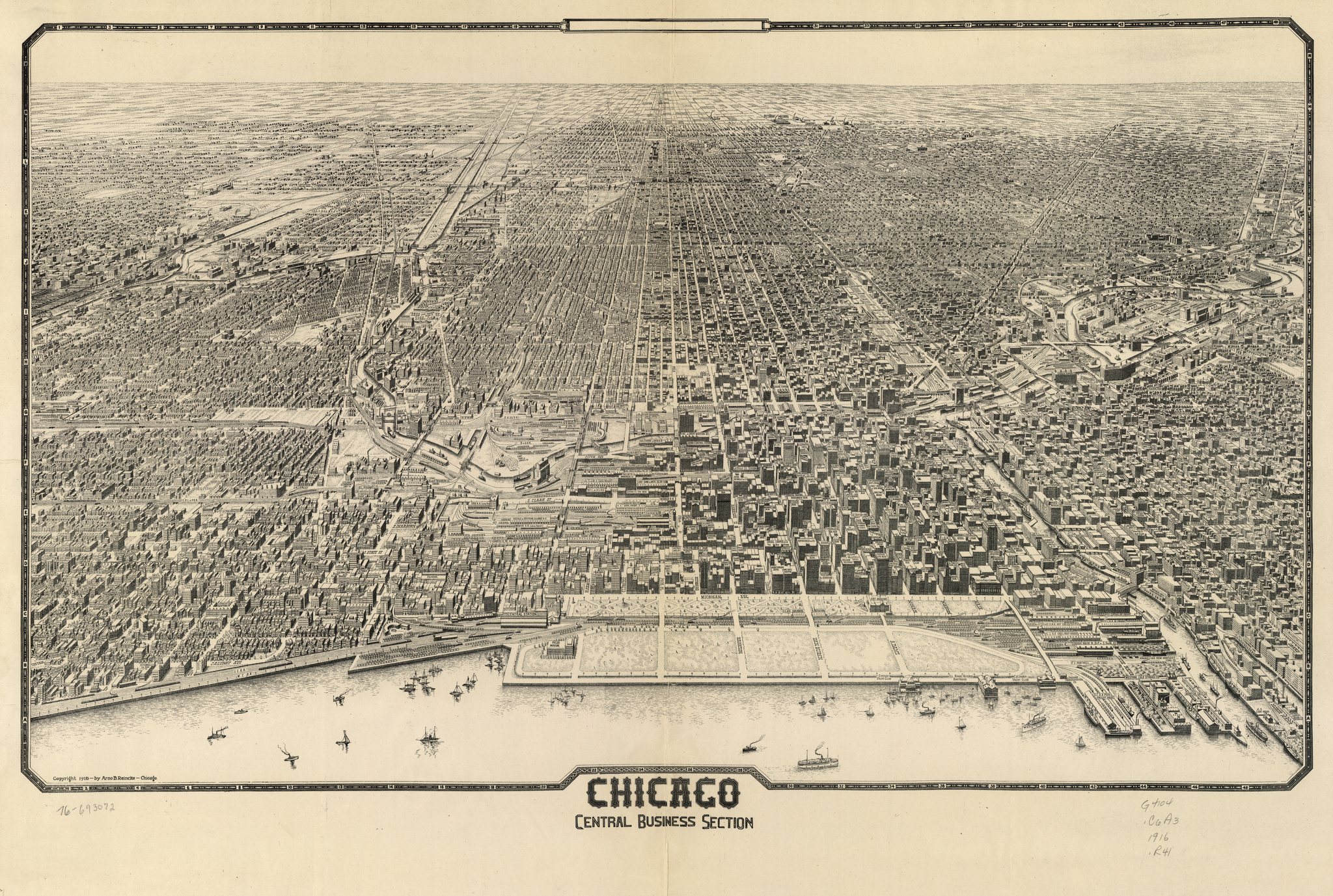
While the Library of Congress' panoramic map collection includes several of Chicago, one in particular stands out as useful for the student of early 20th century industry (the printing machinery industry, in my case): The 1916 map of the "Chicago Central Busines Section" published circa 1916 by Arno B. Reincke. 45 x 75 cm.
This map is available in three versions. The most useful version is a monochrome one, LC Cat No. 76693072, Cal No. "G4104.C6A3 1916 .R41", digital ID "g4104c pm00155". This is online at either http://www.loc.gov/item/76693072 or http://hdl.loc.gov/loc.gmd/g4104c.pm001551
Here it is in a 2048 pixel wide reduced-resolution version (for which click on the image below).
This image isn't really legible, though (it's a big map). Here are two other versions: a PDF (probably the easiest to view, but 133 Megabytes) and a lossless PNG conversion of the full-resolution TIFF as downloaded from the Library of Congress (probably harder to view; 108 Megabytes):
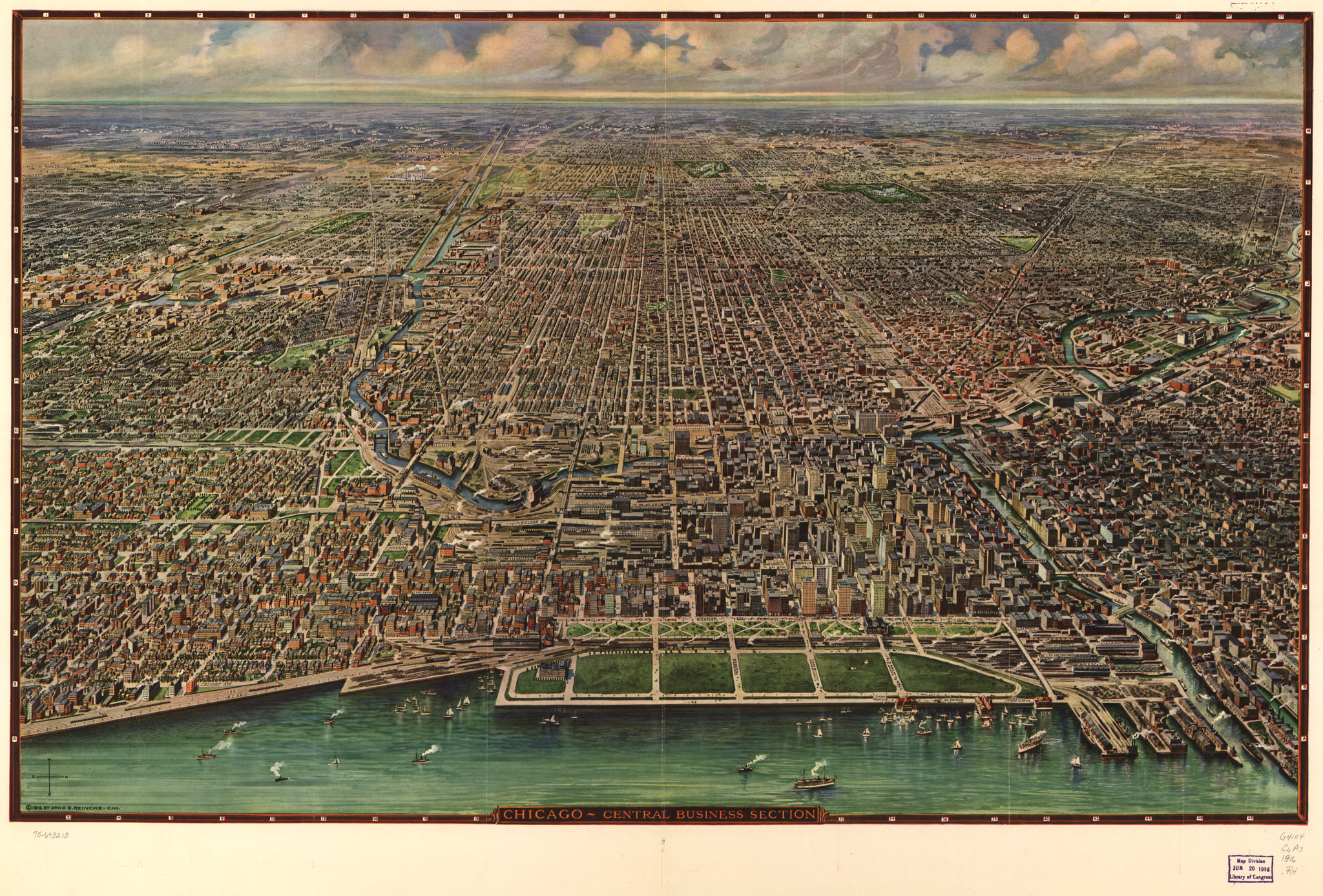
There is also a color version. At first, this looks better, but in fact it is less useful. It isn't quite a colorized copy of the monochrome version; it's a slightly less crisp reworking. It also lacks many of the identifying labels which are present on the monochrome version. (Additionally, the scan of the color version at the Library of Congress isn't quite as sharp as that of the monochrome version.) Its original is 48 x 76 cm.
The color version is LC Cat No. 75693213, Cal No. "G4104.C6A3 1916 .R4", digital ID "g4104c pm001550". This is online at either http://www.loc.gov/item/75693213 or http://hdl.loc.gov/loc.gmd/g4104c.pm001550
Once again, the 2048 pixel wide version won't be particularly useful. Here are full-resolution PDF and PNG versions (138 and 107 Megabytes, respectively).
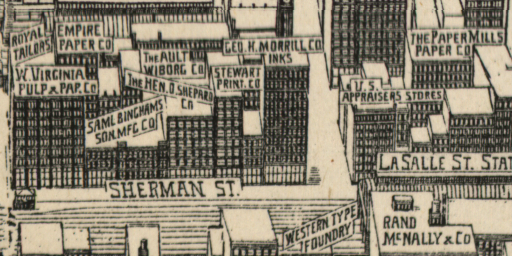
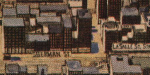
To get a better idea of the differences between the two versions, here are cropped bits showing, more or less, the former "Printers' Row" district.
Here's closer look, concentrating on the section of Sherman Street (now "Financial Place") on which were located the offices of The Inland Printer (Hen. O. Shepard Co.; this building also contained the first offices of the Thomson Type Machine Company), the Ault, Wiborg ink company, Morrill inks, Bingham's rollers, a couple of paper companies (and across the tracks the Western Type Foundry).
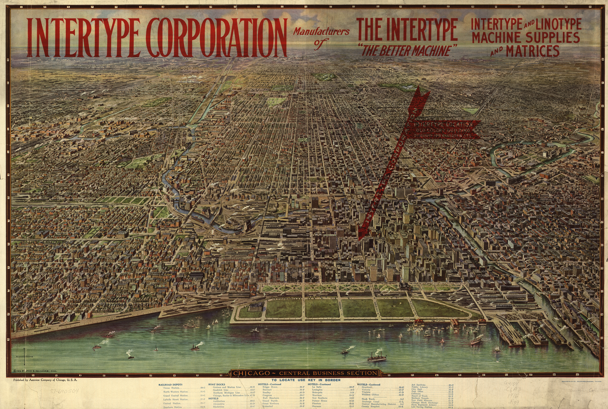
Finally, a third version is of interest primarily for the history of machine composition. It is a version of the color map circulated by the Intertype Corporation (headquartered in Brooklyn, NY) to show the location of their Chicago offices. It also includes a legend listing prominent locations (this legend is not present on the other versions).
The color version is LC Cat No. 87690504, Cal No. "G4104.C6A3 1916 .R39 MLC", digital ID "g4104c pm001552". This is online at either http://www.loc.gov/item/87690504 or http://hdl.loc.gov/loc.gmd/g4104c.pm001552
(It is interesting that the Library of Congress' catalog number for this item is suffixed "MLC" (for Mergenthaler Linotype Company?) Even more curiously, the attribution "Benton Coll." is written in pencil on the lower right-hand corner of this document. The Bentons worked for ATF, not Mergenthaler or Intertype.)
The "Encyclopedia of Chicago" of the Newberry Library and the Chicago Historical Society has a map page with quite a number of maps. See: http://www.encyclopedia.chicagohistory.org/pages/700011.html
The University of Chicago has a good selection of historical and topical maps at: http://www.lib.uchicago.edu/e/collections/maps/
Note particularly the sets of maps of "Chicago in the 1890s" and "Chicago, 1900-1914".
Maps from the ca. 1886 Elisha Robinson Atlas of the City of Chicago are online in the "Fire Insurance Maps" section of Chicago Imagebase, http://tigger.uic.edu/depts/ahaa/imagebase/index.html (However, this site does not appear to have been updated since 1999.)
As of the time of writing (2013), no Sanborn fire insurance maps for Chicago are freely available online (they're digitized; they just aren't freely available). [This section is just a placeholder to remind me to keep checking. The Library of Congress' page on the Sanborn maps is http://www.loc.gov/rr/geogmap/sanborn/]
As of the time of writing (2013), I am unaware of any cadastral (land ownership and location) maps of Chicago available freely online.
There's a handy collection website at http://www.chicagoinmaps.com/ which links to many historical and thematic maps of Chicago (some of which are also noted above, some of which are not).
The street numbers for the City of Chicago were changed in 1909 (for the city outside of the downtown) and then in 1911 (for the downtown/"Loop"). Independently of this, quite a few names of streets have been changed over the years.
(In particular, Sherman Street, one of the most important streets in the former "Printers' Row" district, was renamed "Financial Place" around 1981. {Forgotten Chicago 312})
The information for the 1909 renumbering was published in:
Plan of Re-Numbering, City of Chicago. (Chicago: The Chicago Directory Company, 1909).
A scan of this is online on the Chicago History Museum's website at: http://www.chicagohistory.org/documents/research/resources/1909NumberChanges.pdf
It isn't clear where this scan is from. The original was call no. "F38PA C4M21 Graphics" in the catalog of some library; I haven't found it in the Newberry or the Chicago Public Library online catalogs. Note that there is an overall map of the numbering system on the last page.
This particular copy has an anonymous prefatory page entitled "Chicago Street Numbering System" bound in to (and scanned with) it; this prefatory page is clearly not a part of the 1909 volume.
Note also that this is the same file which is linked from the Newberry Library's rather difficult "ChicagoAncestors.org" site (which merely grabs it from the Chicago History Museum site without telling you where they're getting it from.)
A copy is also online on the Chicago History Society media server at http://chsmedia.org/househistory/1909SNC/start.pdf
The information for the 1911 renumbering of the Loop was published in part of a volume the bibliographic information for which is unknown. The scan, again at the Chicago History Museum website, stripped from it all identifying information (and the website presents none). The only clue is the presence on the first page of data (p. 465) of a call number, possibly from the same library as the 1909 volume (above): "qF38PA C4M2 v.3 Ref" and an accession number "68272". It is online at:
http://www.chicagohistory.org/documents/research/resources/1911NumberChanges.pdf
Note that this anonymized scan is the same file which is linked from the Newberry Library's "ChicagoAncestors.org" site, which further anonymizes it by hiding its source and identity from ordinary browsing.
A copy is also online on the Chicago History Society media server at http://chsmedia.org/househistory/1911SNC/start.pdf
If I may be permitted an editorial remark, while the data in this scan is welcome, its carelessly anonymized scanning and presentation kicks the ladder out from under serious scholarship. Think for a moment how many billions of dollars of real estate this volume represents - yet we have no sound method with proper references to even determine what the street numbers were and are.
Information about the renaming of Chicago streets exists, but once again it has been stripped of its context by the Chicago Historical Museum. All we know from their document is that "The information regarding Street changes was compiled by William Martin in 1948." There is no information at all as to how Martin might have presented this information (the document itself is clearly a modern one).
This document is online on the Chicago History Musuem website at:
http://www.chicagohistory.org/documents/research/resources/streetNameChanges.pdf
Once again this is the same document which is linked, anonymously, from the Newberry Library's "ChicagoAncestors.org" site.
This same document is also availabe on the Chicago Historical Society media server at: http://www.chsmedia.org/househistory/NameChanges/start.pdf
A list with different sources ("a Kirk map of 1937") appears in:
Stiens, Marion B. and Helen Sclair. "Chicago Street Names." Chicago Genealogist, Vol. 29, No. 4 [misprinted as '3' on cover] (Summer, 1997): 120-123.
This issue also contains a single page attributed to the same two authors under the title "Chicago Street Numbering System," but which indicates that it was not by them but "copied from a guide available at the Chicago Historical Society." It is in fact the prefatory text "Chicago Street Numbering System" bound in, and reproduced with the scan of, the 1909 Plan of Re-Numbering, City of Chicago
All of the issues of the Chicago Genealogical Society's Geneaological Quarterly are available online. The index page for them (which includes a link to their scanned contents hosted at the Consortium of Academic and Research Libraries (CARLI) Digital Collections site, is at: http://www.chicagogenealogy.org/digitizedqu.html
(Finally, this same issue contains a one-page list of eight renamed streets in the Town of Pullman compiled by Frank H. Beberdick.)
The Newberry Library's "Chicago Ancestors" website contains digitized street guides and city directories for Chicago for several years between 1866 and 1923. These aren't great scans (they appear to be digitizations of microfilm), but they contain considerable data. See: http://chicagoancestors.org/#tab-tools
There are problems with these, however.
First, the scans of the "street guides" have been stripped of their bibliographic information. It is not possible to use them in a proper scholarly context because you have no way of citing the source of your data. The best you can do is to hyperlink back to these presentations of extracts from unknown sources. (The closest thing they give is a set of introductory pages from the 1923 Polk's Chicago Directory, but it is by no means clear that all of the "street guide" extracts are from editions of Polk's.) Each of the "street guides" appears to be a section from a city directory.
The "city directories" do have their introductory pages, which is good. However, they suffer from a different problem: as presented there they are inaccessible. It would seem that the builders of this website tried to do a clever presentation in which only an introductory page is visible on the website. The actual content, while hosted on the site, is hyperlinked through these PDF-format intro pages. Naturally, the PDF links as coded do not work, and the directories themselves are inaccessible.
Finally, the Newberry Library asserts new copyright on all of these scans of public domain documents. As I try to be particularly careful about these issues, this means that I cannot just reprint them here to make them actually available.
Many city directories (scanned from microfilm, typically) are available on Don Kriger's " donslist.net" site. These seem to include those also presented on the "Chicago Ancestors" site (see above).
The Chicago-"L".org site ( http://www.chicago-l.org/) has quite a bit of history on the system. This can be very useful when researching old industrial locations. (The 'L' once conducted freight operations as well as carrying passengers.) See: http://www.chicago-l.org/history/index.html
The "Forgotten Chicago" website is frequently useful: http://forgottenchicago.com/
A complete digitized run of The Chicagoan from 1926 to 1935 is available online (but not public domain) at the University of Chicago at: http://chicagoan.lib.uchicago.edu/xtf/search?static=home
In the 1890s and 1900s, the Inspectors of Factories and Workshops of the State of Illinois issued a series of Annual Reports. These are very useful for determining whether a company was in business and where they were located. An incomplete selection of them is online via Google Books. Here are local copies of several of the Google Books PDFS:
Similarly, the Biennial Report[s] of the Auditor of Public Accounts to the Governor of Illinois contain useful business information. Some of them are available via Google Books. Here's a local copy of one that I happened to use:
{Forgotten Chicago 312} "312 '72" [a "street necrology" of the 312 area code as of ca. 1972] on the website: http://forgottenchicago.com/articles/312-72/
All portions of this document not noted otherwise are Copyright © 2014 by David M. MacMillan and Rollande Krandall.
Circuitous Root is a Registered Trademark of David M. MacMillan and Rollande Krandall.
This work is licensed under the Creative Commons "Attribution - ShareAlike" license. See http://creativecommons.org/licenses/by-sa/3.0/ for its terms.
Presented originally by Circuitous Root®
Select Resolution: 0 [other resolutions temporarily disabled due to lack of disk space]


